

Kathmandu, Bagmati Province
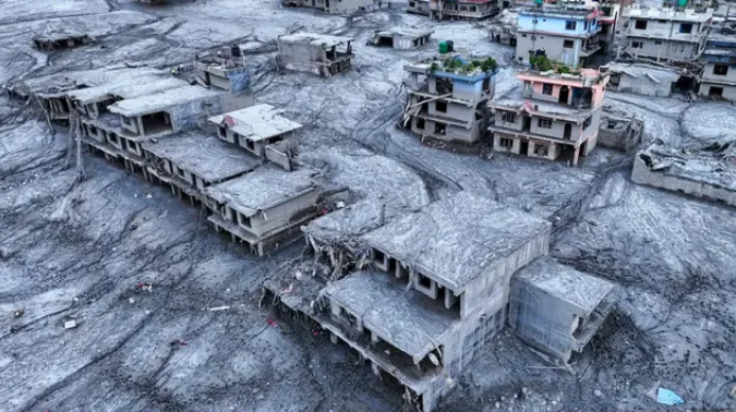
A major natural disaster in the Himalayan region along the Nepal-China border on the morning of August 26 quickly turned into a devastating catastrophe. Following an incident involving a glacier and a massive landslide at an altitude of more than 5,000 metres, a huge volume of water, ice and debris rushed down the mountains.
The powerful flow travelled through river valleys for nearly 100 kilometres, affecting several areas of Nepal.
At 8:37 a.m. Nepal time, or 8:22 a.m. Indian time, seismic activity was recorded in the Himalayan region. The event was initially reported as a magnitude 4.4 earthquake. However, different scientific institutions later presented varying analyses of what had actually happened.
The United States Geological Survey (USGS) said the event was caused by a massive glacier-related landslide in Nepal’s Langtang National Park region. According to the USGS, the energy released by the landslide was equivalent to that of a magnitude 5.2 earthquake.
On the other hand, India’s remote sensing centre said in its preliminary assessment that a magnitude 4.9 earthquake on the Tibetan side may have triggered the glacier collapse. The two assessments have led to different scientific interpretations regarding the initial cause of the disaster.
The International Centre for Integrated Mountain Development (ICIMOD) has also stated that the exact trigger of the event has not yet been fully determined. Therefore, it would be premature to conclude whether the disaster was directly triggered by an earthquake or whether a massive landslide and another glacier-related event produced the seismic signals.
Following the incident, a massive flow of water, ice, soil and rocks rapidly moved downhill through river channels. The force of the mountain rivers was so intense that normal river flows suddenly transformed into destructive flooding in several areas.
The floodwaters continued to carry enormous amounts of debris downstream, damaging riverbank areas and affecting communities along the route.
After moving through Nepal’s river systems, the flow continued towards the Narayani River basin. Authorities also increased their level of alert over the rising water levels and potential flood impacts further downstream towards India.
The disaster serves as a major warning about the fragile geographical conditions of the Himalayan region, where glaciers, unstable mountain slopes and sudden floods can combine to cause widespread destruction within a very short period of time.